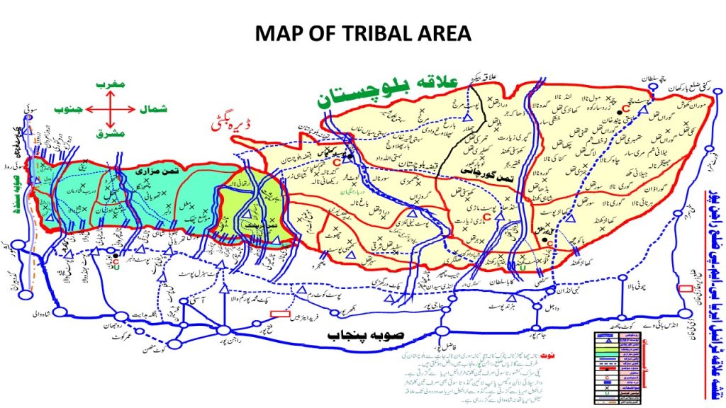
Rajanpur District, located in the southwestern part of Punjab, Pakistan, is a region rich in cultural heritage and agricultural significance. “Rajanpur” has been named after its Headquarter town, Rajanpur, which was founded by a Sheikh Rajan Shah in 1732-33. The new District of Rajanpur was carved out of the old D.G. Khan district.
The word “Rajanpur” posses a kind of romantic dignity in its name. Its history is shrouded in myths and legends. The only original source of its history is the worn out revenue record of the late Tehsil of Rajanpur. After studying the general details of the various records and registers relating to the revenue settlements of different tracts of the region one can hardly discover even casual facts about the origin and evolution of the chronicles of this district. Though the region of the district and the area around must be as old as the Indo-Pak subcontinent, yet its history is largely a narration of missing sequence on account of its political isolation and geographical seclusion from the main lands of the country. Many chronological links appear to be broken from the chain of historical facts. It should, therefore, be quite interesting to understand the possible reasons of these historical gaps obstructing the opportunity of events and the seclusion of the area from the rest of India.
However these possible generalizations should not lead to the conclusion that Rajanpur district has no history worth the name. The following facts are of vital importance to the historical development of the district.
Rajanpur was founded in 1732-33 by Makhdoom Sheikh Rajan, who ousted the original Nahar Possessors, and made himself master of their estates. Rajanpur was an unimportant village until 1862, when the town of Mithan Kot was washed away by the Indus, and the headquarters of the Assistant Commissioner was transferred thence. “(The imperial Gazetteer of India Page 270).
Historical Background:
The ancient history of the Rajanpur District is not known and only some events of historical importance could be traced before the conquest of Sindh by the Muslim army, led by Mohammad Bin Qasim.
Before the advent of the Muslim in Sindh, the Rajanpur District area had only three main towns, Asni, Harrand and Mari which were petty habitations without any particular historical or commercial significance. The rest of the area of the District was almost without human habitations. Two of these towns i.e. Asni and Harrand are connected with the stories of legendry heroes Rassolo and his arch opponent Raja Sirkap.
The principal events relating to the earliest period of history of Rajanpur are possibly connected with the military exploits of the invaders of India. On his way from India, Alexander’s armies sailed in the river Indus which flowed along the Eastern zone of the district through the Tehsils of Jampur, Rajanpur and Rojhan. Famous historian V.A. Smith states.
“He (Alexander) had comprehensive plans and ordered his Naval Commander who led the voyage down the river Indus from Jhelum to the sea coast in ten months, to sail the fleet to the Persian Gulf around the sea coast up to the Euphrates. He also directed him to write the details of the countries and area through which he might pass.”
The Details of the voyage are not available now but the presence of the Indus is a witness to the fact that Alexander’s armies sailed through the river along the Eastern side of the district. Megasthenus, the Greek historian, also recorded that before Alexander the great left Indus, he bestowed the Government of Kabul and the territories on the western bank of Indus, including whole of the area of Dera-Jat to his famous general Selucus. After Chandar Gupt Murriya defeated and expelled the Greeks from India, the whole of this region went under the sway to the Murriya Dynasty.
The next event of the historical importance concerning this district has its connections with the conquest of Muhammad Bin Qasim in 711-12 A.D. The present district of Rajanpur formed the part of Raja Dahir’s Kingdom and his son Fauzi or Faugi governed it from Kashmore (as the seat of his government). The capital of Raja Dahir was Alor or Alvor near Bakkar. The Arabs after occupying this region settled down in the newly acquired lands including the present district of Rajanpur. Muhammad Bin Qasim or a regiment of the Arab army had marched up to Harrand situated in the North-West of the district, because the style of construction of the Harrand Fort, which covers an area of about 8 sq. miles has great similarity with the garrison posts housing the Arab armies during their rule over Sindh.
After the annexation of this area by the Arabs, the historical events of this region cannot be traced with certainty.Sultan Mahmood of Ghazni in 1026 A.D. in his 17th invasion routed the Jats who escaped across the river and settled down in and around the district. These Jats who inhabited the district till their migration after independence belonged to the most ancient races of India and General Cunningham called them “Zaths”. He believed that they were the original inhabitants in or about 1482 A.D. by Ghazni Khan Mirani, the Baloch founder of the town of Dera Ghazi Khan. The Mahars, however, continued to hold on the southern strip of their states but during the reign of Nadir Shah they were finally expelled from Sitpur by one Makhdoom Sheikh Rajan who was employed by them as an agent to their property. In the southern portion of their domain (now part of the district) their authority was challenged by the uprising of Mazari Baloch which is said to have taken place in A.D. 1733. Mahars are presently settled in Kashmore, Barkhan and Harrand.
Eighteen century was an era of political instability and there had been turmoil and turbulence throughout the sub-continent. Due to the continued chaos and turmoil in the country some of the Muslim leaders of the sub-continent in their effort to meet the rising threat of the Marhatas. One of such prominent figures was Makhdoom Shiekh Rajan, who had established himself at Sitpur as a protégé of Nadir shah and later Ahmad shah Abdali against the Marhatas with men, money and material. He was confirmed by both of them as a Governor of Sitpur. His state included the present territories of District Rajanpur.
Makhdoom Sheikh Rajan was the younger of the two sons of Sheikh Syed Hassan Bukhari also known as “Hazrat Buland Rajan”. He was a man of great plenty and as well as known as a religious saint. He enjoyed the reputation of a “Wali “and had a very large following among the masses. He was one of the greatest religious personalities of his time.
History Makhzan-e-Punjab states,
“The Lingahs of Multan gave one of their daughters in marriage to him (Sheikh Syed Hassan Bukhari). The Lingahs also presented a large state around Sitpur as wedding gift to their daughter.”
Of the two sons of the saint, the elder one Syed Munib Shah died during the life time of the saint. Consequently Makhdoom Sheikh Rajan succeeded to both the spiritual and political ancestry of his father. The son, however, distinguished himself from his father by asserting his power in the domain of politics rather than the spiritual world inherited him by his father. After succeeding his father, Shiekh Rajan faithfully served the Mahars of Multan who recognized him as a ruler of the State of Sitpur. But gradually with the passage of time, the Nahar started losing their influence and Makhdoom Sheikh Rajan began to assert himself as an independent ruler. He developed special relation with Nadir Shah Durrani. History Makhzan-e-Punjab at page 342 affirms,
“He (Makhdoom Sheikh Rajan) gained wealth from Nadir Shah and secured the government of the area from him as a province of his Kingdom.”
Misl-e-Haqiat (Record of Rights) 1872 also affirms the contents of the History Makhzan-e-Punjab. It records,
“In the first instance, this area was an uninhabited jungle and was under the occupation of none. About five generations corresponding to nearly 130 years Makhdoom Sheikh Rajan resident ruler of Sitpur state now district Muzaffargarh was awarded this area by Ahmed Shah, the king of Khurasan in return for digging Nala Qutab and for inhabiting and colonizing the area. He then added the word ‘Pur’ to his name Rajan and called it Rajanpur. Since then the area continued to grow in population through further colonization and immigration from outside.”
On the basis of evidence recorded in Misl-e-Haqiat in 1872 A.S. the foundation years of the town of Rajanpur can be calculated as 17-32-33 A.D. this town was situated in the vicinity of a small village known as “Their” in the local dialect meaning a place ruined by an earth-quake or a thunder-bolt. The place where the first man built his habitation was somewhere in the middle of the present town. It is said that he was a Hindu and had built a very small temple as well near his house.
Sheikh Makhdoom Rajan was a very seasoned statesman, a brave soldier and a remarkable administrator. He assessed the quality of soil and embarked upon a well planned program of colonizing the whole of the area under his governance. He undertook several measures to make the area self-sufficient in agriculture. He induced his followers and friendly tribes to settle down in the area for the purpose of agriculture. He awarded them on various terms and conditions of sharing the total product. The revenue records of 1872 state that he encouraged the immigrants to share agriculture produce with him in lieu of free allotment of land. He introduced a well integrated system of water channels for the purpose of irrigation and encouraged the sinking of wells all over the area where the land could be irrigated by the canal system.
The measures brought fruitful results and the area became economically prosperous in a very short time. He administered justice and held his court at Sitpur with dignity and decorum. His court was an attraction for the men of letters and a number of literary figures had gathered in his court. The record of history is again silent about the events after the death of Makhdoom Sheikh Rajan. It appears that after his death the kingdom fell apart and came under the influence and occupation of petty tribal chiefs scattered all over the area.
Makhdoom Sheikh Rajan had developed intimate relationship with Nawab Muhammad Bahawal Khan of Bahawalpur State. He was also on good terms with Nawab Hayat Ullah Khan, the sobedar of Multan. He was a very active member of the alliance which was headed by Rawal Rai Singh and included Nawab Hayat Ullah to recapture Fort Derawar. He won name and fame in this campaign, enhanced his power and prestige as a ruler of Sitpur. He displayed remarkable skill of diplomacy in finding favor with the conquerors like Nadir Shah and Ahmad Shah Abdali. His association with them was indeed very close and intimate. He had remarkably adjusted himself in the ebb and flow of the politics in that age of blood and iron. He served nadir Shah faithfully and loyally throughout his life. After the death of Nadir Shah, Ahmad Shah Abdali willingly owned him as faithful and loyal military commander. He served him both militarily as well as politically. In reward thereof, he secured the Jagirs covering the territories of the Sitpur including the present District of Rajanpur. After Makhdoom Sheikh Rajan, the history can be read with reference to three distinct phases which finally ended with the British establishing administrative control over the territory.
After the death of Rajan Shah, a number of tribal chiefs had established themselves in small tribal pockets throughout the district. In 1758 A.D. Harrand and Dajal were two such principal settlements which had been inhabited by Gurchani and Lund tribes. Both these tribes refused to submit to the authority of the governors appointed by Taimur Shah Durrani. Taimur Shah while fighting against the Marhatas was assisted by Nadir Khan Berohi, the Khan of Kalat. When the Marhatas were defeated in the conflict, Taimur Shah awarded this area to him with an instruction to maintain law and order in the land. The area, therefore, remained under the possession of Khan of Kalat until 1827A.D. when it was conquered by the Sikhs.
“In 1758 A.D. Taimur Shah, son of Ahmed Shah Durrani, was expelled from the Punjab by the Marhatas under Ragoba, Nasir Khan Berohi, Khan of Kalat, revolted against Ahmed Shah just as he was about to march to recover the Punjab. Nasir Khan was defeated. After his defeat, he joined Ahmed Shah against the Marhatas. In return of the aid so timely rendered, Ahmed Shah Best owed the Harrand and Dajal Ilaka upon him.” (District Gazetteer Dera Ghazi Khan Page, 19).
The history of disintegration of Mughal Empire in India and the story of annihilation of the political power of the Marhatas is closely linked with the rise of Sikh power in the Punjab. After the death of Guru Teigh Bahadur, the Sikhs in Punjab had become restless and were simmering with discontent. They were growing fast as a powerful military threat under Guru Gobind Singh. However, they were not a consolidated political power till Ranjeet Singh established himself as their leader. In 1799 A.D. Zaman Shah the Abdali ruler of Afghanistan had appointed him as Governor of the Punjab. He was elevated to this position of power and prestige in view of his military service rendered for Zaman Shah in his campaigns against the Marhatas.
After the down-fall of Abdali rulers of Afghanistan Ranjeet Singh began to expand his power and installed himself as ruler of Punjab in 1805 A.D. his conquering hoards annexed the whole of Punjab to the west bank of the river Sutlej during his life time. The British hedged the expansion of his power by the treaty of Amritsar in 1809 A.D. thus the whole of the territories to the west of river Sutlej came under his influence.
Ewan Mulraj was the last governor of the Multan who was appointed by Ranjeet Singh and continued in this position till he was ousted by the British. In 1819 A.D. Ranjeet Singh advanced up to Dera Ghazi Khan and annexed it into his kingdom, however, he bestowed this area to Nawab Sadiq of Bahawalpur for as a “Nazrana” of Rs. 100000/- and a sum of Rs. 400000/- per year as Khiraj. In 1828 A.D. The Nawab conquered Dajal and Harrand which remained under his control till 1830 A.D. After that Swan Singh was appointed as Military Commander of Harrand outpost. It was under him that the old fort of the town of Harrand was thoroughly repaired and renovated. He also built a new fort at Drigri and rebuilt the old fort of Asni. He fortified them with strong military contingent in order to clear the area from the predatory.
However under the apparent peace and tranquility, the Gurchani and the Mazari tribes were preparing for a revolt. Immediately after the Harrand fort was rebuilt by Sikhs, Gurchani tribe burst out against them by murdering the warden of the fort. The situation became tenser when Sikhs appointed Bijar Khan as chief of Gurchanis against the will and wishes of tribe. Under these circumstances, the Gurchanis under their chief Ghulam Haider Gurchani, welcomed the advance of the Britain in A.D. 1845 and aided them against Sikhs. Mazari another powerful trive in this region also resisted the expansion of the Sikh power. They had specialized in operating on the principle of hit and run tactic against the Sikhs who had been trying to assert their political ascendency in the newly conquered territory. Under their chief Behram khan, the Mazari did not come under the influence of Sikhs and remained a potent force to oppose the Sikh rule thought their occupation, till 1849 A.D.
The Britishers reached Punjab and defeated the Sikhs in a series of battles in 1848-49 A.D. They forced Mulraj, the Dewan of Multan to surrender the force which was occupied by the British without a contest. After the conclusion of the second Sikh war, Multan was annexed by the British and General Cortland became the first Deputy Commissioner of the district of Multan. After the fall of Multan in 1849 General Cortland occupied Dera Ghazi Khan and the British began to advance towards the territories of the present District of Rajanpur. The British forces were offered stiff resistance by Mokham Chan who served as Kardar under his military commander Sawan Singh stationed at Harrand. He was holding the fort with a force about 200 men. The British under Lt. Ralph young advanced swiftly aided the fort and occupied it. They were assisted by the Gurchanis in their advance against the fort of Harrand. Sawan Singh was killed in the battle and the entire region lay open for the British advance.
Though the British had annexed the present district of Rajanpur, yet they were not able to establish their firm grip over the area. Generally, the whole of the district remained disturbed for a long time after the annexation. The principal tribe which resisted the British advancement was the Buzdar who had settled in the hills. The British accused them of plundering the caravans but in fact they had broken out in the open defiance against the British authority. A force of 500 men commanded by General H.S. Hodgson was sent against the Buzdars. He was then replaced by General Chamberlain in March, 1857 A.D. who after a pitched battle overpowered and subdued them.
The War of Independence of 1857 A.D:
When the war of independence 1857 sparked, this area was far from the being quiet and peaceful. Alarmed by the situation which had developed as a result of the war of Independence, the British took all precautionary measures to meet the possible threat of an uprising in the area. At that time Captain Hughes was commanding First Punjab Cavalry at Asni. Besides Asni, Harrand and Muhammad Pur were other two outposts established to defend the area.
According to the narrative of Captain Pollock who was stationed there during 1857, his first step was to summon Captain Hughes, commanding First Punjab Cavalry at Asni. In a few hours this officer was there with 300 sabers, but his services being needed elsewhere, Captain Pollock was directed by the chief commissioner to raise a levy of 300 horses and 300 foot soldiers to guard the outposts. The people showed great alacrity in joining these levies. The Mazaris, however, took opportunity to make a raid upon the Asni border. In August, 1857 A.D. Body of the 230 horsemen came down into the plains and were met by Bijar Khan Darishak, and body of Bugti and others, and out of a force of 60 men they lost their chief, Bijar Khan, his son and 38 men/ in recognition of the conduct of Darishaks, a pension of Rs. 100/- per annum was granted to the late Chief Miran Khan.
“Abode of Khosa horsemen was sent to operate against the rebels, out the leader, Sikandar Khan Khosa was badly chosen and the party returned after going no further than Montgomery. In 1867, an attack known as the Harrand raid was made upon British the head of 1200 men and was repulsed by a body of Gurchani and Tibbi Lound Tribesmen. Leaded by their chiefs and aided by the sabers from the garrison of Harrand for.
The Rule of Crown:
After the Bugtis had been pushed back out of the British territory the area became quite peaceful for a long time. The British then had a breathing space to introduce an effective system of administering the newly acquired area and to exercise effective control and maintain peace and order. The whole administrative system in the area was organized under Frontier Crimes Regulation. The remaining area came under the general system of administration introduced elsewhere throughout India. A special officer under the designation of Political Assistant was appointed with his Headquarters at Dera Ghazi Khan and he was made responsible for administering the Tribal Area of District. To govern the area through local chiefs the British introduced the Tummandari System in the District immediately after the headquarters of Assistant Commissioner but in 1862, the headquarters were shifted to the town of Rajanpur till it became the headquarters of Rajanpur District on 1st July, 1982. The Tummandari system introduced by the British is still prevalent on the tribal area of Rajanpur District.
Tummandari system introduced in the district resembled with Akbar’s Mansabdari system, A Tummandar was almost equal to a Mansabdar in the Mughal Period. The whole district was divided into several Tummans and their geographical limits were almost identical to the area occupied by the respective tribe. In Baloch Tummans, the Tummandar was the supreme judicial Authority. Murders were settled on the Wani Bani, Women or Land Principle. Cases of theft were met by restoration of property. The tribal area of the Rajanpur District presently divided into the following three Tummans.
Tumman Gurchani comprises the area inhabited by the people belonging to Gurchani tribes some of Lunds are also settled in this area. That time the following Border Military Police Posts were established in this Tumman:-
The area inhabited by the Darishak tribe has been included into Tumman Darishak. That time the following Border Military Police Posts are established in this Tumman:-
Mazaris are the principal tribe living in the area. Their Tumman had the following Border Military Police Posts:-
Rajanpur District lies entirely west of the Indus River, bordered by Dera Ghazi Khan District to the north, Dera Bugti District (Balochistan) to the west, Muzaffargarh and Rahim Yar Khan Districts to the east, and Kashmore District (Sindh) to the south. The Sulaiman Mountains rise to the west of the district, adding to its diverse topography.
Established: July 1, 1982
Headquarters: Rajanpur City
Tehsils:
Jampur
Rajanpur
Rojhan
Population: Approximately 2.32 million
Urban Population: 26.5%
Literacy Rate: 36.09% overall; 43.68% for males and 28.18% for females
Languages:
Saraiki: 76.67%
Balochi: 17.77%
Urdu: 2.61%
Punjabi: 2.28%
Religious Composition:
Islam: 99.73%
Christianity: 0.21%
Others: 0.06%
The district’s economy is predominantly agricultural, relying heavily on canal irrigation due to minimal rainfall. Major crops include cotton, sugarcane, wheat, rice, and tobacco. Rajanpur is particularly noted for its cotton production, supporting numerous textile mills in the region.
Mithankot: Home to the shrine of Sufi poet Khawaja Ghulam Farid.
Fazilpur: Location of the shrine of Peer Chan Charagh Shah Sain, also known as Ghorrey Shah Sain.
Harrand Fort: A historical fort built during the British era.
Maari: A hill station in Rajanpur, offering cooler climates and scenic views.
Rajanpur has experienced significant flooding, notably in July 2015, when heavy rains led to flash floods affecting multiple union councils. The floods caused extensive damage to homes, agriculture, and infrastructure, highlighting the district’s vulnerability to natural disasters.
Hill Torrents Flood
There are 6 major Hill Torrents in District Rajanpur namely but two Hill Torrents (kaha & Chachar) are active for the last 10 days.
The Hill Torrents come from catchment area of Koh Suleman ranges with maximum capacity of one lac cusecs & enters through various darras i.e kaha, chachar, sori etc to hit the major towns. i.e Dajal , Hajipur, Lalgarh in thesil Jampur & Asni in tehsil Rajanpur & Mauza Mat, Dilbar etc of Tehsil Rojhan. This rain water enters the settled area and causes huge damage to crops, land, canal irrigation system and local population.
River Indus Flood
During Monsoon season, the Indus River carries excessive flood water which results inundation. It causes huge loss to the crops, livestock and local population in the adjoining area of River Indus. Major towns exposed to the river Indus are Jampur, kotla Mughlan, Bait Sountra, Mehray wala, kotla Androon, Noshehra, Kot Mithan, Umer kot and Rojhan. Flood History Chart
Policy Interventions / Policy Paper:
In view of the recent unprecedented torrential rainfall in the Koh-e-Suleman mountains, there is a dire need of devising a holistic and comprehensive flood fighting mechanism to avoid future disaster if any in Rajanpur District and nearby areas. Torrential flood water coming from D. G. Khan and adjoining areas finally flow down to River Indus by passing through Rajanpur District. This make this district quite vulnerable to flood risk every time. To address this problem, a proper flood protection mechanism is required to mitigate flood risks even in case of more unprecedented rainfall events.
Hazard Map:
Risk and vulnerability assessment is an important first step in disaster risk management (DRM) and is the basis for formulating DRM policies.
Hazard Map is a live Google map developed locally under the wise guidance of Deputy Commissioner Rajanpur during the flood season of 2022 (25th August 2022).
During the floods, District Administration Rajanpur, NGOs and INGOs were not able to reach the most vulnerable areas due to stagnant water ponds and inaccessible road network.
The main purpose of mapping is to plot flood damages data on Google Earth, identify problematic areas and facilitate evacuation of people and delivery of relief items on priority basis.