KOT MITHAN
THE INDUS RIVER
The Indus River is one of the longest and most historically significant rivers in Asia, flowing through China (Tibet), India, and Pakistan. With a total length of approximately 3,180 kilometers (1,976 miles), it is the lifeline of Pakistan.
The Indus River is one of the longest and most historically significant rivers in Asia, flowing through China (Tibet), India, and Pakistan. With a total length of approximately 3,180 kilometers (1,976 miles), it is the lifeline of Pakistan, supporting agriculture, providing drinking water, and shaping the cultural and economic landscape of the region for millennia.
The river originates in the Tibetan Plateau, near Lake Manasarovar in China. From there, it flows northwest into Ladakh (India), and then enters Pakistan through Gilgit-Baltistan, traveling the length of the country before emptying into the Arabian Sea near Karachi.
Geography and Course
Source: Lake Manasarovar, Tibet (China)
Flows Through:
Tibet (China)
Jammu & Kashmir and Ladakh (India)
Pakistan (Gilgit-Baltistan, Khyber Pakhtunkhwa, Punjab, Sindh)
Mouth: Arabian Sea (near Thatta/Karachi, Sindh)
Indus River System of Pakistan
Pakistan River System (Tributary Rivers, Barrages, Headworks and Dams)
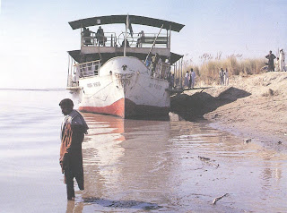
Indus River and Kot Mithan:
The Indus River is one of the most significant rivers in Pakistan and Kot Mithan located in the Rajanpur District of Punjab, lies near this mighty river. Five rivers Jhelum, Chenab, Ravi, Beas and Sutlej merge near Mithankot. The river plays a critical role in the local ecosystem, economy, and agriculture of the region, but it also presents challenges due to its occasional flooding, especially during the monsoon season.
Geographical Importance: Kot Mithan is situated on the western bank of the Indus River, making the river an essential part of the town’s geography and daily life. The Indus is a lifeline for the region, providing water for agriculture, drinking, and transportation.
Agriculture and Economy: The fertile lands around Kot Mithan, nourished by the Indus River’s waters, are ideal for growing crops. Agriculture is the primary livelihood for many people in the region, and the river’s seasonal flooding can deposit nutrient-rich silt onto farmlands, boosting crop yields. The river provides irrigation water for the cultivation of crops such as wheat, cotton, rice, and sugarcane.
Flooding Risk: The Indus River is prone to flooding, particularly during the monsoon season. When the river swells due to heavy rainfall or snowmelt from the northern regions of the country, it can overflow its banks and inundate nearby settlements, including Kot Mithan. This flooding can cause significant damage to homes, infrastructure, and farmland, as well as displace communities.
Historical Significance: The Indus River has been central to the history of the region for centuries. It was the site of the ancient Indus Valley Civilization, which flourished along its banks thousands of years ago. This ancient civilization developed advanced systems of water management, which were critical for agriculture and urban planning. Today, the river still holds cultural and historical significance for the local population.
Transport and Trade: In earlier times, the Indus River was a crucial route for trade and transportation, especially for carrying goods such as agricultural produce and textiles. While road and rail transport have largely replaced river transport today, the river still plays an important role in local movement and trade.
Environmental and Ecological Role: The Indus River supports a diverse ecosystem, including various species of fish and birds. The wetlands and riparian zones along the river are essential for biodiversity, providing habitat for both migratory and local species. However, human activity, pollution, and climate change have increasingly threatened the health of the river and its surrounding ecosystems.
Indus Water Treaty: The Indus Water Treaty between Pakistan and India, signed in 1960, governs the distribution of the waters of the Indus River and its tributaries. Under the treaty, Pakistan has control over the three eastern rivers (the Indus, Jhelum, and Chenab), while India has control over the three western rivers (the Ravi, Beas, and Sutlej). This treaty is crucial for maintaining peaceful and equitable water distribution between the two countries, as the river system is a shared resource.

Late 19th century (1917-1992)
1992 – 2016

February 2017
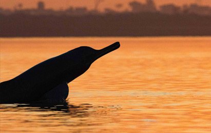
Indus River Dolphin
Indus river dolphins are found mostly in the lower parts of the Indus River in Pakistan. The dolphins historically swam freely through about 3500 km of the Indus River system from the Indus estuary, through the plains to the foothills of the Karakoram mountains1, 2. The dolphins’ range has been reduced by approximately 80% due to the construction of irrigation barrages, and now most of the remaining animals are in a 690 km stretch of the Indus River in three separated populations3. A handful of Indus river dolphins also occur in the Beas River in India, trapped above an irrigation dam4.
The most recent estimate of abundance for the Indus river dolphin, based on surveys conducted in 2017, was close to 2000 animals5.

Biology and Ecology
Indus river dolphins are light brownish-grey, though they sometimes exhibit lighter undersides. They have a long thin rostrum with many long teeth that are visible even when their mouths are closed. Their dorsal fin is rather small compared to other river dolphins, and is more like a triangular hump. They have large flippers and flukes, and flexible necks.
This species is functionally blind. Therefore, like other dolphin species, it relies heavily on echolocation to navigate and hunt1, 6. Externally, the eye appears to be barely larger than a pinhole, restricting light from reaching the retina, there is no lens, and the optic nerve is very narrow, leading scientists to conclude that their eyes are incapable of forming clear images, but that they may still serve as light receptors6.
Indus River Dolphin. Illustration by Uko Gorter
Reproduction and growth
Indus river dolphins reach sexual maturity when they are approximately 10 years old7. Mating occurs throughout the year but births appear to peak between March and May1. After a gestation period of 8-9 months, a single calf is born, generally around 70cm in length, and feeds on milk from the mother7. They can grow up to 2.5 metres in length and weigh 70-110 kg. Limited data is available about their lifespan, but the oldest known animal was 39 years3.
Diet
The Indus river dolphin eats a large variety of prey including river prawns, catfish and carp1.
Behaviour
Like Ganges river dolphins, Indus river dolphins have developed a unique side swimming behaviour which is an adaptation to help them navigate through shallow waters6. Although the dolphins have occasionally been found in groups consisting of as many as 30 individuals, they are mainly solitary9.
Individuals are at the surface for only about 1 second, and they then dive for just over a minute9. Like other dolphin species, they navigate using echolocation, but reflecting the complexity of the river environment, Indus river dolphins emit sound almost constantly. Generally, these animals are shy towards humans.
Refernces
- Anderson, J. (1879). Anatomical and zoological researches: comprising an account of the zoological results of the two expeditions to western Yunnan in 1868 and 1875 and a monograph of the two cetacean genera Platanista and Orcella (Vol. 1 – Text and Vol. 2 – Plates): Bernard Quaritch, Piccadilly, London.
- Reeves, R. R., & Chaudhry, A. A. (1998). Status of the Indus River dolphin Platanista minor. Oryx, 32(1), 35-44.
- Braulik, G. T., Smith, B. D., & Chaudhry, A. A. (2012). Platanista gangetica ssp. minor. In The IUCN Red List of Threatened Species. Version 2014.3: http://www.iucnredlist.org. Downloaded on 23 April 2018.
- Behera, S. K., Nawab, A., & Rajkumar, B. (2008). Preliminary investigations confirming the occurrence of Indus River dolphin Platanista gangetica minor in River Beas, Punjab, India. Journal of the Bombay Natural History Society, 105(1), 90-126.
- Aisha, H., Braulik, G., Khan, U., Leslie, A., & Nawaz, R. (2017). Indus River dolphin (Platanista gangetica minor) – an update on the current assessment and conservation challenge. Working Paper presented at the International Whaling Commission, Bled, Slovenia, 2017. SC/67A/SM/22.
- Herald, E. S., Brownell, J. R. L., Frye, F. L., Morris, E. J., Evans, W., E., & Scott, A. B. (1969). Blind river dolphin: first side-swimming cetacean. Science, 166, 1408-1410.
- Brownell, R. L. (1984). Review of reproduction in Platanistid dolphins. Report of the International Whaling Commission(Special Issue 6), 149-158.
- Braulik, G. T., Bhatti, Z. I., Ehsan, T., Hussain, B., Khan, A. R., Khan, A., et al. (2012). Robust abundance estimate for endangered river dolphin subspecies in South Asia. Endangered Species Research, 17, 201-215.
نَچدی رئی سرکار فریدا
ڈُب گئی روہی یار فریدا
چار چوفیرے پانی دِسے
لوک پَھسے وچکار فریدا
کچے کوٹھے کیویں چُکن
ایس بارش دا بھار فریدا
ساڈے ناں دی سرخی لگی
ویکھ ذرا اخبار فریدا